


OUR SERVICES
- Topographic surveys
- Boundary surveys
- Road surveys
- Route surveys
- Establishing M.S.L on site
- As built surveys
- Existing building surveys
- Industrial and infrastructural development surveys
- Rural and urban development surveys
- Oil, sewerage, gas line, pipeline etc surveys
- Setting out surveys
- Quantity calculation
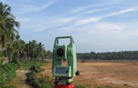
Topographic surveys
To locate the existing details such as buildings roads, trees, electric post etc, to find the actual shape of the property, to find the difference in elevation of the existing ground by spot levels, and contour lines, which will give you to design your ideas in a very easiest and accurate way.
Boundary surveys
To find the actual shape and area of the existing property. To re-establish or recover the property boundaries as per the original document.
Road surveys
This survey is for making proposed roads, widening of existing roads, any development on road sides, making new bridges canals etc. we will provide the sectional details with the topographic plan which will help the architect/engineers to design.
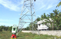
Route surveys
To locate the position or alignment of existing transmission lines, cables, pipelines, oil lines, etc with the details of the existing ground.
Setting out
From our initial site surveys, architects and engineers can produce detailed design and layout drawings. From these drawings we are able to return to site and accurate lay position and setout buildings, roads and all other structural or other requirements. Our survey team have experienced in most disciplines including housing,developments, roads, pipelines and large civil engineering projects.
As built building surveys
Our team is experienced in producing a range of detailed drawings from the existing building with m.m accuracy.
We supply
- Site plan
- Detailed floor plans
- Detailed sections
- Detailed elevations
- Photographs (on request)